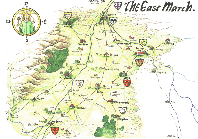
Map of the East March
This is a map of the area around Tanaloth, immediatly to the south of the Holy City. This is commonly known as the East March, and is divided into dioscee belonging to the various Archons. To the south the main road runs over the Lambey heights to Lambey, to the east it continues over the desolate moors to Scarsmouth, and to the East it runs into the mountains to eyjafjord.
This map was made for Sir Ina, Sir Skeggi, Deacon Olvar, Deacon Eirik and Father Eilif by the monks of Korforth Abbey.
Click on the map for a larger version (360k)
Map of the Lands of Tanaloth
This map shows the whole landward extent of the lands of Tanaloth, from the Holy City in the north to the lands of Stenabreck to the south. Beyond Stenabreck are said to lie the heathen lands, the ruins of the ancient Sendalite kingdomms from which the exodites fled. In the bottom corner of the map is indicated St. Sendar, a holy ruin long abandoned in heathen lands.
This map was made for Sir Ina, Sir Skeggi, Deacon Olvar, Deacon Eirik and Father Eilif by the Cathedral Scribes and is not totally accurate in either distances or detail (for example it shows only those towns lying directly on the road the from Tanaloth to Stenabreck
Click on the map for a larger version (240k)

Map of the Inner Sea
This map shows the inner sea, the islands lying close to Tanaloth. These are Kendal, Hellister, Wyre (the pirate isle) Eregal (the cursed isle) and Kirbister (the plague isle). In the center of the map is Jormundgan, the serpent of the inner sea. To the immediate south of this map lies Tanaloth, while to the North East lies Stonsay.
This map was bought by Sir Ina, Sir Skeggi, Deacon Olvar, and Deacon Eirik while on the isle of Wyre. It was drawn during the first summer of the war on Eregal.
Click on the map for a larger version (180k)
